

What is LiDAR Technology: Revolutionizing the Way We See the World
Introduction
In today’s fast-paced world, technology is constantly evolving, opening up new possibilities and changing the way we interact with the world around us. One such groundbreaking technology that has been making waves in recent years is LiDAR. Short for Light Detection and Ranging, LiDAR has been transforming industries ranging from autonomous vehicles to archaeology. In this article, we will delve into the fascinating world of LiDAR technology, exploring what it is, how it works, and its various applications.
Understanding LiDAR Technology
LiDAR technology is a remote sensing method that uses laser light to measure distances and create detailed, three-dimensional maps of the environment. It operates on a simple principle: a laser scanner sends out laser pulses, and a sensor measures the time it takes for the pulses to bounce back after hitting an object. By precisely measuring the time it takes for the laser pulses to return, LiDAR can calculate the distance to objects with remarkable accuracy.
How LiDAR Works
LiDAR systems consist of several key components, including a laser scanner, a GPS receiver, an inertial measurement unit (IMU), and a computer for data processing. Here’s how the process works:
Laser Emission: The LiDAR system emits rapid laser pulses towards the surrounding environment.
Reflection: When the laser pulses encounter objects, they bounce back (reflect) towards the LiDAR sensor.
Time Measurement: The sensor measures the time it takes for each laser pulse to return.
Data Collection: As the LiDAR system moves or rotates, it collects a multitude of distance measurements, creating a point cloud of data.
Data Processing: The collected data is then processed to create detailed 3D maps and models of the environment.
Applications of LiDAR Technology
LiDAR technology has found applications in various fields, and its versatility has made it an invaluable tool in numerous industries. Here are some of the key areas where LiDAR is making a significant impact:
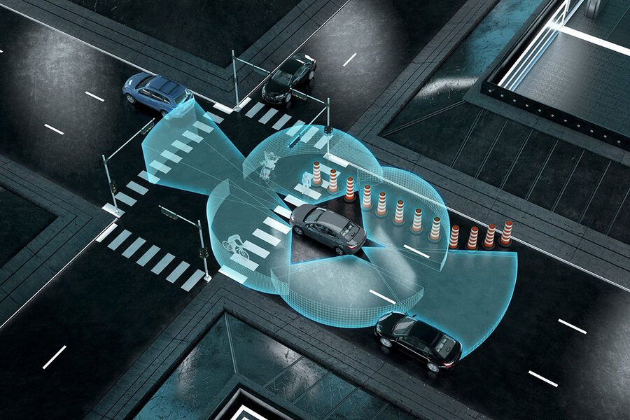
1. Autonomous Vehicles
LiDAR is a critical component of self-driving cars and autonomous vehicles. By providing real-time, high-resolution 3D maps of the vehicle’s surroundings, LiDAR enables these vehicles to navigate safely and make informed decisions, helping to reduce accidents and increase road safety.
2. Archaeology and Cultural Heritage
In archaeology, LiDAR has revolutionized the way researchers study historical sites and landscapes. By scanning vast areas from the air, LiDAR can reveal hidden archaeological features, such as ancient ruins, roads, and settlements, that are not visible from the ground.
3. Forestry and Environmental Monitoring
LiDAR is widely used in forestry and environmental monitoring to assess tree density, measure forest height, and monitor changes in vegetation over time. This technology aids in forest management and conservation efforts.
4. Urban Planning and Infrastructure
City planners and engineers utilize LiDAR data to create accurate 3D models of urban environments. This information is invaluable for designing and maintaining infrastructure, optimizing traffic flow, and planning for sustainable urban development.
The Future of LiDAR Technology
As technology continues to advance, the future of LiDAR technology looks promising. Here are some exciting developments to look forward to:
1. Miniaturization
LiDAR systems are becoming smaller and more compact, making them suitable for a wider range of applications. Miniaturized LiDAR sensors are finding their way into consumer devices, such as smartphones, enabling enhanced augmented reality experiences and gesture recognition.
2. Increased Accuracy
Ongoing research and development efforts are focused on improving LiDAR’s accuracy and range. This will further enhance its capabilities in applications like autonomous vehicles and geological surveying.
3. Cost Reduction
As demand for LiDAR technology grows, manufacturers are working to reduce production costs. This will make LiDAR more accessible to a broader range of industries and applications.
4. Integration with Other Technologies
LiDAR is increasingly being integrated with other sensing technologies, such as cameras and radar, to provide comprehensive perception systems. This fusion of data sources enhances the overall performance of autonomous systems.
Conclusion
LiDAR technology has emerged as a transformative force in various industries, offering precise 3D mapping capabilities and aiding in the development of cutting-edge applications like autonomous vehicles and archaeological research. As technology continues to evolve, we can expect LiDAR to play an even more significant role in reshaping the way we perceive and interact with our world. Whether it’s for enhancing road safety, uncovering hidden historical treasures, or advancing environmental conservation efforts, LiDAR technology is paving the way for a brighter and more connected future.